Discovery of Raigarh | Mysahar.in

About Raigarh Chhattisgarh.
Raigarh is a beautiful and well-known city located in Chhattisgarh. Which was established at the beginning of the eighteenth century. Which is known for its historical-cultural heritage. Once upon a time, this city used to be the legacy of the ancestors of Maharaja Chakradhar Singh. During the reign of Chakradhar Singh, he gave more priority to the Kathak dance and music of the city, due to which is today called the “Cultural Capital of Chhattisgarh”.
And every year Chakradhar ceremony is organized in his memory. Which is a well-known festival in Chhattisgarh. Raigarh is also well-versed in steel production. More than 40 steel power plants, including big and small ones like Jindal Steel Power Plant, and Ind Synergy Power Plant, are established in this city. The Jute Mill of the city is also included of the oldest mills in India.
In 2011, about “3 lakh 64 thousand” people lived in this city, which is “1 lakh 85 thousand” at present. There is a sex ratio of 985 females for every 1000 males. And the people here use Hindi, Chhattisgarhi, and Odia languages.
Famous Roads.
- Odisha Road
- Dhimrapur Road
- Chandrapur Road
- Ambikapur Road
- Bilaspur Road
- Kotra Road
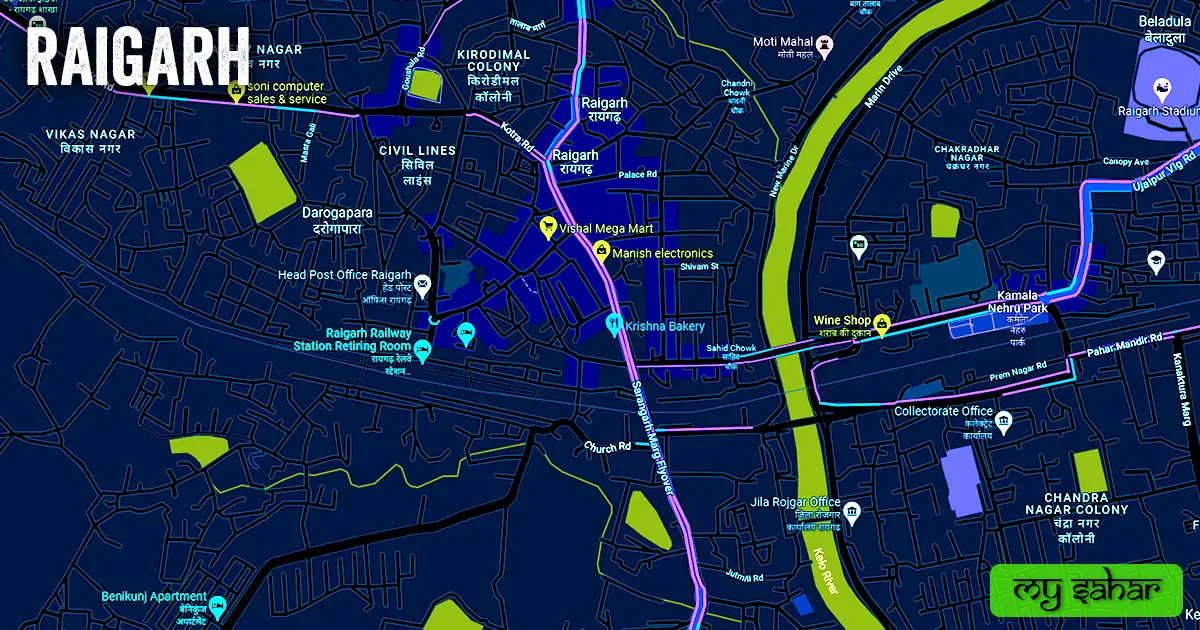
- Marin Drive
- Station Road
- Goushala Road
- Jindal Road
- Collectorate Road
- Rambhata Road
- Pahad Mandir Road
- Mahatma Gandhi Road
Famous Chowks.
- Dhimrapur Chowk / Seth Kirodimal Chowk
- Buji Bhawan Chowk
- Chandani Chowk
- Lal Tanki Chowk
- Ganja Chowk
- Sahid Chowk
- Shubhash Chowk
- Ghadi Chowk
- Gandhi Chowk
- Gouri Shankar Mandir Chowk
- Railway Station Chowk
- Kabir Chowk
- Kashiram Chowk
- Chatamuda Chowk
Rivers And Lakes.
- Kelo River
- Karbala Talab
- Ganesh Talab
- Bhujbandhan Talab
- Garden Talab
- Fataha muda Talab
- There are major sources of water here.
Ways Of Transportation.

Transportation is an essential element for the development of any city, which connects the city with many other cities and also makes trade easier. The following are the means of transportation here. The major ways of transportation here are roads, rail roots, and airways.
Roads – NH-49, Bilaspur Highway, and Ambikapur Highway are the three National Highways and State Highways passing through this city, which connect Sarangarh, Kharsiyan, Gharghoda, Dharamjay Garh, and Jhadsuguda to this city.
Railways – This station is a part of the (South East Central Railway) and the station code of this station is (RIG), which connects to several cities via rail routes. The length of this station is about 661.45 meters and the width is approximately 77.05 meters. There are 3 platforms located here that handle all the trains.
Airways – The nearest airport to this city is “O.P. Jindal Airport”, which is a private airport of a private company (Jindal Steel Plant) in this city. The nearest domestic flight airport from this city is (Bilasa Devi Kewat Airport) which is located 155 km away from here in Bilaspur city.
Pin Code Of City.
City pin codes are 6-digit postal codes that are used to identify a specific geographic location within a city in India. Often people also search on Google for its pin code. The full form of a Pin Code is (Postal index number code). And city’s headquarters pin code is – “496001”
Distance From Major Cities.
- Korba – 89 km
- Bilaspur – 132 km
- Rourkela – 156 km
- Ambikapur – 190 km
- Raipur – 196 km
- Bhilai – 226 km
- Durg – 232 km
- Ranchi – 257 km
- Cuttack – 284 km
- Rajnandgaon – 320 km
Latest Weather Updates.
Temperature does not have much effect in this city as the average maximum temperature here is 33.3° C and in winter the average temperature is 21.4°C. here on average, Rainfall is 1587 mm (62.4 inches) every year. To get today’s weather information, click on the link given below.
- www.accuweather.com
- timesofindia.indiatimes.com
- weather.com
News Agencies.
A list of some famous local news agencies is given below. These include newspapers, magazines, local news channels, etc.
- Haribhomi
- Harsh News Channel
- Navbharat
- Dainik Bhaskar
- Nyay Sakshi News Paper
- RGH News
- Sanchar Kranti
- The College Today
Best Parks.
- Kamla Nehru Park
- Kelo Dam Park
- Park Avenue Colony, Jindal Road
- Piravran Park
- Lochan Nagar Park
- Ganesh Talab Park
- Ayushi Agarwal Park
- Jai Jhulelal Vatika
- Pushpa Vatika Children’s Garden
- Pandit Deen Dayal Upadhyay Udyan
Best Hospitals.
- Shri Balaji Metro Hospital
- Sanjeevani Nursing Home
- Venus Multi-Specialty Hospital
- Apex Super Specialty Hospital and IVF Centre
- Harsh Children Hospital
- Government Ayurveda Dispensary, Chandmari
- Kanha Hospital
- Shree Siddhivinayak Skin Care and Maternity Clinic
- Siddhartha Hospital
- Kirori Mal Government Hospital
Best Hotels.
- Hotel Trinity Grand
- Hotel Ansh International
- Hotel Accord Premier
- Hotel Shrestha
- Hotel Jindal Regency
- Hotel Shri Sai Shraddha
- Hotel Sunshine
- Hotel Pathik
- Hotel Johal Palace
- Hotel Janki
Best Schools.
- Government Natwar School
- OP Jindal School
- Carmel Convent School
- Delhi Public School
- Sadhu Ram Vidya Mandir
- Kendriya Vidyalaya
- Indian School
- Lions Public School
- Sanskar Public School
- Maa Sarveswari Higher Secondary School
Best Colleges.
- Government PD College
- OP Jindal Institute of Technology
- KMT Government Girls College
- Jindal Institute of Power Technology
- Uttam Memorial College
- Kirori Mal Government Polytechnic College
- Erikant College of Education
- Raigad City College
- Janaki College of Education (JCE)
- Kirori Mal Government College
Geography Of Raigarh.

The area code of Raigarh is “7726” Its height is about 219 meters above sea level. Here the registration of vehicles is done in “CG-13”. The area of this city is 27 square kilometers. There is a total of “6 Police Stations” located in this city.
Official Government Websites.
- Official website of the city – Click here.
- Nagar Nigam’s Website – Click here.
- Official Police Website – Click here.
Famous Areas Of City.
- Bhagwanpur
- Boirdadar
- Kelo Vihar
- Mahapara
- Daroga Para
- Chandani Chowk
- Ampal
- Sankar Nagar
- Rajiv Nagar
- Vikas Nagar
- Itwari Bazar (Sunday Market)
- Civil Line
- Lochan Nagar
- Kirodimal
Famous Places To Visit.
Tourist Attractions –
- Jagdamba Fun World
- Grand Mall
- Galaxy The Mall
- Alok City Mall
- Panchdhari Water Check Dam
- Madosilli Waterfall
- Smart Bazar
- 1 India Family Mart
- Koili Ghagar Waterfall
Temples & Mosques –
- Budhi Mai Mandir
- Chandrahasni Mata Mandir
- Gauri Shankar Mandir
- Pahad Mandir
- Emli Bhavan (Baba Dham)
- Sai Mandir
- Shahi Edgah
- Jama Masjid
- Raja Masjid
Food, Bar & Cafes –
- Domino’s Pizza
- Chaupati Shaupati
- Shrinath Pawbhaji Center
- Kinara Bar
- Keki Bar
- Noor Jahan Biryani Center
Movie Theaters –
- Carnival Cenemas Grand Mall
- Gopi Talkies
- R.K. Entertainments Multiplex
- Ram Nivas Talkies
- Galaxy Cinemas
Facts About Raigarh.
Raigarh is known for its coal mines and industrial activities. This city has a rich history and was formerly called Jhagarh, which was later changed to Raigarh after the Raigadh Fort. It was once ruled by the Kalchuri dynasty. The city is famous for its brass handicrafts and handloom sarees. One of the largest power plants in India, the Jindal Steel and Power Limited, is situated here. Raigarh celebrates various festivals, including Hareli, Pola, and Navakhai, reflecting its unique culture.