Muzaffarpur | Bihar | Mysahar.in

About Muzaffarpur Bihar.
Muzaffarpur is one of the famous cities of Bihar. Which is known for its politicians and celebrity faces. It is also a major producer of steel utensils and spoons. Giant sugar mills are also located here. At the same time in the agricultural sector, the royal litchis who produces here are famous in the whole country, here about “Three Lakh Tonnes” of litchis are produced every year, which is so much that it is exported to other cities and states as well.
It was established in the year 1875. Which was named after the person named Muzaffar Khan who founded it. In the 5th century From 401 to 500 BC, it was known as “Vaishali”. The city is the birthplace of eminent personalities like George Fernandes, Janaki Ballabh Shastri, and Rajendra Prasad.
According to the census, Approx of “3 lakh 93 thousand” people live in Muzaffarpur. In which there is a sex ratio of 890 females for every 1000 males. The people here use Hindi, Urdu, Bihari, and Maithili languages in their daily life.
Famous Roads.
- Tajpur – Samastipur Road
- Ramdayalu Nagar – Hajipur Road
- Bheldi Road
- Bajpatti – Rasalpur Road
- Sitamarhi Road
- Akharaghat Road
- Ramgarh Road
- Deoria Road
- Purani Motihari Road
- Station Road
- Purani Naka Road
- Kalambagh Road
- Pakki Sarai Road
- Sanjay Cinema Road
- BB Ganj Road
- Stadium Road
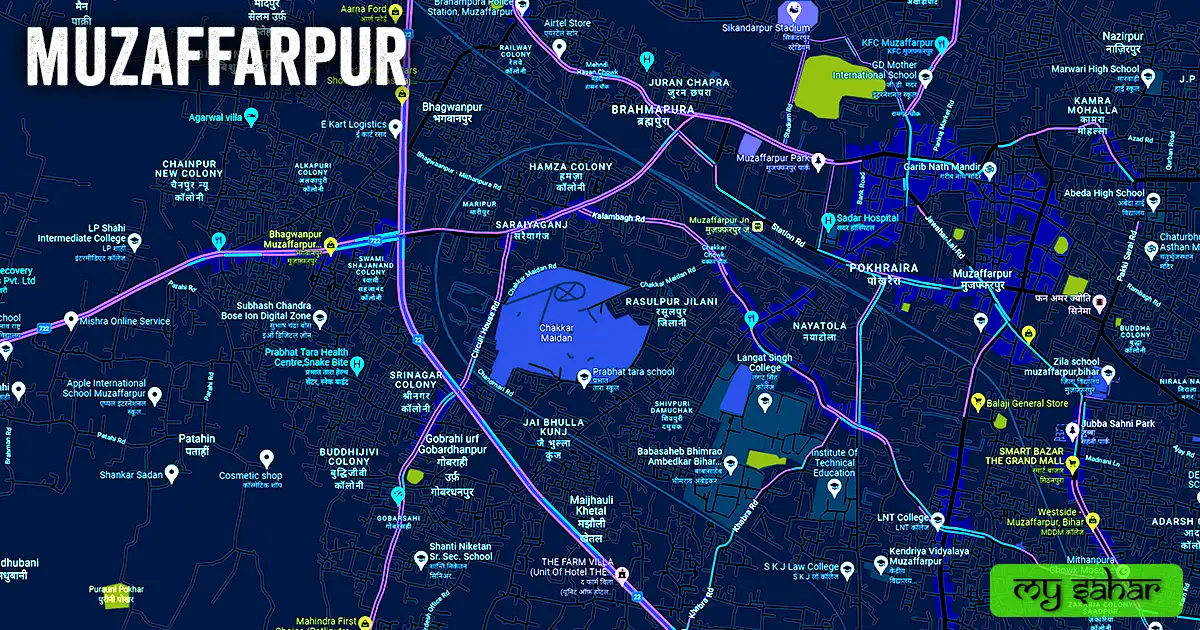
- Chakkar Maidan Road
Famous Chowks.
- Ramgarh Chowk
- Chakkar Chowk
- Saraiyaganj Tower Chowk
- Bhagwanpur Chowk
- Jokhan Rai Chowk
- Bairia Chowk
- Aghoria Bazae Chowk
- Banaras Bank Chowk
- Dharamshala Chowk
- Zumma Masjid Chowk
- Mahesh Babu Chowk
- Chandani Chowk
- Saraswati Chowk
- Kila Chowk
- Chandra Chowk
- Speaker Chowk
- Jail Chowk
- Khadi Bhandar Chowk
Rivers And Lakes.
- Budhi Gandak River
- Sikandarpur wetland Pond
- Maharaji Pokhar
- Ghirni Pokhar
- Paraao Pokhar
- RDS College Pond
- Natural Pond
- Pokhra
Ways Of Transportation.

Transportation is an essential element for the development of any city, which connects the city with many other cities and also makes trade easier. The following are the means of transportation here. The major ways of transportation here are roads, rail roots, and airways.
Roads – The NH-27, NH-22, NH-722, and Asian Highway 42, are the four national highways that pass through this city and connect big cities like Samastipur, Hajipur, Chapra, Motipur, Sitamrhi, and Darbhanga together.
Railways – This city has a big station located in the middle of the town, the station code of this railway station is (MFP), which is a junction with routes to several cities and has a total of 8 platforms. The length of this station is about 978.68 meters and the width is about 115.63 meters. A total of 89 trains run at this railway station.
Airways. – Unfortunately, this city doesn’t have any working airport so people have to go to its nearest located airport which is (Jaiprakash Narayan Airport) Which is located 76.1 km east of here in the state capital Patna.
Pin Code Of City.
People also search on Google what is the pin code of this city. The full form of a Pin Code is Postal Index Number Code. And the pin code of the city’s head office is – “842001”.
Distance From Major Cities.
- Darbhanga – 50 km
- Patna – 64 km
- Arrah – 95 km
- Bihar – 104 km
- Munger – 134 km
- Gaya – 153 km
- Mau – 185 km
- Bhagalpur – 187 km
- Kathmandu Nepal – 178 km
Latest Weather Updates.
It has an annual average high temperature of 30.5°C and an average minimum temperature of about 20.3°C. And it receives an average of 1,147 millimeters (45.1 in) of rain every year. Click on the links given below to get today’s weather information for this city.
- Weatherbug.com
- City.imd.gov.in
- Justweather.org
News Agencies.
A list of some famous local news agencies is given below. These include newspapers, magazines, local news channels, publishers, etc.
- Hindustan Times
- Dainik Bhaskar
- Den News
- Tirhut News
- NNB Live Bihar
- Sudama NewsPapers
- Muz News
Best Parks.
- Muzaffarpur Park
- Bharat Mata Naman Sthal
- Orient Club Field
- Mahatma Gandhi Udyaan
- Jubba Sahni Park
- APARO Multiservices
- Mahatma Gandhi Koop udyaan
- Shambhu Park
- Sahara Bharat Mata Park
- Khabra Children Park
Best Hospitals.
- Prasad Hospital
- Heart Hospital
- Maa Janki Hospital & Research Centre
- Glocal Hospital
- RBM Hospital Pvt. Ltd.
- It Memorial Hospital
- Prashant Memorial Charitable Hospital
- Minakshi Multi Specialty Hospital
- Ashoka Hospital
- Mishra Hospital And Test Tube Baby Centre
Best Hotels.
- The Royal Phular
- Hotel Embassy International
- Hotel Simna International
- JJK Rukmini Vilas Hotel & Banquet
- Hotel Minakshi International
- Grand Fort Hotel & Banquet Hall
- Hotel Grand Madhav Palace
- Hotel Kailash Tower
- Hotel Buddha Imparial
- Hotel Kanishka International
Best Schools.
- G.D. Mother International School
- Resonance International School
- The Oxbridge Public School
- North Point Children’s School
- Delhi Public School
- Prabhat Tara School
- Pristine Children’s High School
- Kendriya Vidyalaya
- Shanti Niketan Sr. Sec. School
- M. S. Public School Sadpura
Best Colleges.
- R.B.B.M College Muzaffarpur
- L. S. College Gate
- Langat Singh College
- Sonu Online Center
- Ram Dayalu Singh College
- Nitishwar Mahavidyalaya
- Dr. Jagannath Mishra Mahavidyalaya
- Rameshwar College
- MIT Muzaffarpur
- LNT College
Geography Of Sehore.

The area code of its head office is – (0621). Its height is about (60 meters) above sea level. Here the registration of vehicles is done in “BR-06”. The area of this city is (51.20 km²) and the border is about 33.73 km. There’s a total of “15 Police Stations” situated in this city.
Official Government Websites.
- Official website of this city – Click here.
- Municipal Corporation’s website – Click here.
- Official Police Website – Click here.
Famous Areas Of City.
- Saadpur
- Nai Bazar
- Brahmpura
- BhagwanpurMajhauli Khetal
- Jaiprakash Nagar
- Sadatpur
- Pokhraira
- Hamza Colony
- Saraiya Ganj
- Girja Nagar
- Paigambarpur Kolhua
- Adarsh Colony
- Basant Bihar Colony
- Chak Ghazi
- Sadhugachhi
- Shekhpur
- Bairia
- Sriram Nagar
Famous Places To Visit.
Tourist Attractions –
- P&M Mall Muzaffarpur
- Ramchandra Shahi Museum
- The Grand Mall
- Makjid-e-Belal
- Muzaffarpur Park
- D.R.B Mall
- Reliance Trends
- U B TOWER
- APARO Multiservices
- Saraiyaganj Tower
Temples & Mosques –
- Garibnath Temple
- Garib Nath Mandir
- Mithanpura Chowk Mosque
- Jama Masjid Madhopur
- Maa Raj Rajeshwari Devi Mandir
- Baba Someshwar Nath Mandir
- Mughal Masjid
- Chhinmastika Mandir
- Mughal Masjid
- Shri Rani Sati Mandir
Restaurants & Cafes –
- The Cakes Cafe
- Brewbakes Restaurant
- Cafe Balboa
- Kesariya Food Court Food Parlour
- Ratna Cafe
Movie Theaters –
- Cinepolis Muzaffarpur
- Eylex Cinemas
- Fun Amer Jyoti Cinema
- Shekhar Cinema
- Shakuntla Cinema Hall