Khargone | Madhya Pradesh | Mysahar.in

About Khargone Madhya Pradesh.
Khargone is a city located 125km far away from Indore, In the state of southern Madhya Pradesh, which is growing rapidly on the path of development. Khargone is known for its agriculture, chili, cotton manufacturing, cigarette manufacturing, rice and pulses cultivation, dye manufacturing, and its ancient temples, palaces, and tombs. However, Khargone is known all over the country, especially for its famous Navagraha temple.
And for this special temple, a popular fair is organized here every year in December and January, which is being done for many years. Khargone was formed on 1 November 1956, at that time it was known as West Nimar. It is also said that it got its name because of the dense neem trees in this area. although no concrete evidence has been found for this.
That’s why only because of this it got its name Nimar. Finally, on 25 May 1998, after the division of Nimar into two parts, Khargone City came into existence. Which was nothing less than a gift for the people here. Khargone is also the headquarters of Khargone district where major government bodies are located such as the collectorate, police department, etc.
And the biggest thing is that Khargone has got the title of “India’s Fastest Moving City” as well as “Clean City” which has been given many times, which makes this city different and special from other cities. According to the 2011 census, about “1 lakh 16 thousand” people lived here, where there is a sex ratio of 945 females for every 1000 males.
Famous Roads.
- Major Abdul Hamid Road
- Tilakh Path
- Mahatma Gandhi Road
- Mangrul Road
- Damkheda Road
- Jawahar Road
- Jhanda Chowk Road
- Eidgaah Road
- Sanjay Nagar Road
- Gausala Road
- Bus Stand Road
- BTI Road
- Indore Highway
- Khandwa Highway
- Sanawad Road
- Julwaniya / Barwani Road
- Likkhi / Thikri Road
- Bhagwanpura Road
- Burhanpur Highway
Famous Chowks.
- Jhanda Chowk
- Talab Chowk
- Gayatri Mandir Square
- Parshuram Circle
Rivers And Lakes.
- Kunda River
Ways Of Transportation.

Transportation is an essential element for the development of any city, which connects the city with many other cities and also makes trade easier. The following are the means of transportation for Khargone. The major ways of transportation here are roads, rail roots, and airways.
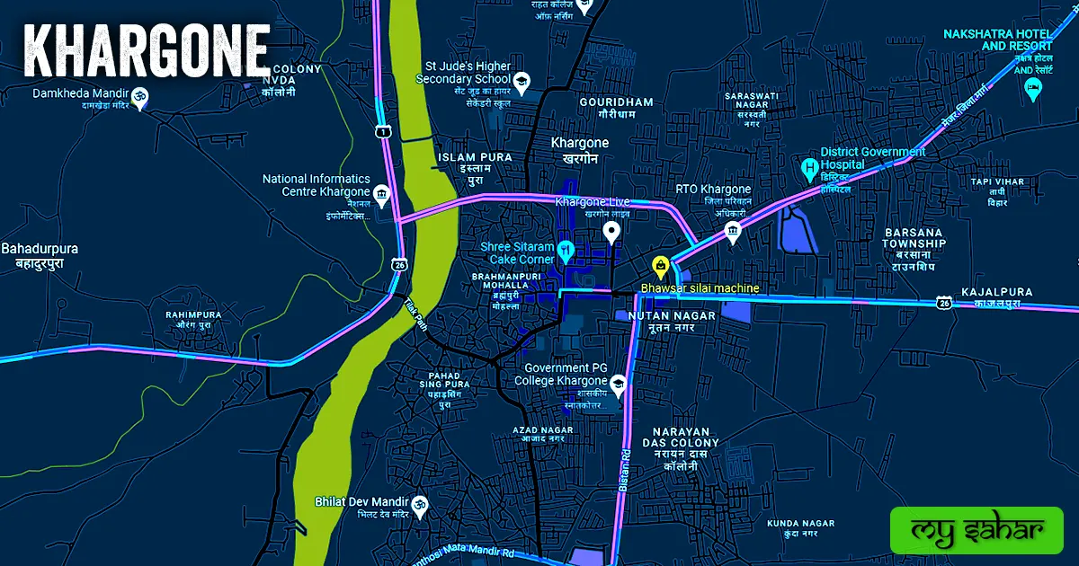
Roads – SH-26, SH-31, and SH-01 are the three major state highways that pass through Khargone, which connect this city to big neighboring cities like – Julwania, Kasrawad, Barud, Bistan, and Gogawan together.

Railways – Khargone doesn’t have its own railway station. so if any case of train journey here people have to travel all the way its nearest railway station called (Khandwa Junction). Its station’s station code is (KNW). this station is situated 87.2 km away from here in the Khandwa area and it takes 2 hours and 21 minutes to reach there.
Airways – Khargone does not have its own airport. so for any flight people have to go to its nearest airport known as (Indore Airport) but first, you have to travel all the way 127 km far away in the north direction from here in the Indore city. It takes hardly 3 hours and 4 minutes to reach there.
Pin Code Of City.
people also search on the internet that what is the pin code of Khargone. The full form of the PIN Code is Postal Index Number Code. And the pin code of the city’s Head Office is – “451001”
Distance From Major Cities.
- Sanawad – 68 km
- Khandwa – 87 km
- Indore – 103 km
- Dhule – 132 km
- Dewas – 137 km
- Ujjain – 153 km
- Ratlam – 176 km
- Malegaon – 179 km
- Akola – 188 km
- Aurangabad – 217 km
Latest Weather Updates.
The average temperature of Khargone is around 45°C in summer and 21°C in winter. And here on average 914mm (36 inches), every year of rainfall happens. It rains here for about 27.6 days every year. For today’s weather information about Khargone, click on the link given below.
- Weather.com
- Timesofindia.indiatimes.com
- Meteoin.ru
News Agencies.
A list of some famous local news agencies in Khargone is given below. These include newspapers, magazines, local news channels, etc.
- Rajexpress
- Bhaskar News
- Naidunia
- Khas Khabar
- Navbharat Times
- Hindi News18
- Prabhat Khabar
- Desh Gaon News
Best Parks.
- Sneh Vatika
- Taigore Park
- Basant Vihar Garden
- Gokul
- Sunder Park Garden
- Atal Park
- Hariyali Garden
- Shiv Shakti Nagar Park
- Vindhya Vihar Garden
- Azad Nagar Garden
Best Hospitals.
- Veermani Institute Of Gastroenterology
- Subhishi Hospital
- Vijaylaxmi Hospital
- Sharda Hospital
- Ramshree Hospital
- Manav Seva Hospital
- Maa Memorial Hospital
- Shubh Dental Clinic
- Viraj Hospital
- District Government Hospital
Best Hotels.
- Nakshatra Hotel And Resort
- Hotel Indigo Innternational
- Hotel President
- Oyo Vallabha Hotel
- Hotel Utsav Palace
- Hotel Shakti Avenue & Restaurant
- Hotel Gopal
- Hotel Swastik
- Hotel Yuvraj
- Hotel Shri Kasturi
Best Schools.
- Gokuldas Public School
- Saifiyah secondary school
- Swami Vivekanand School
- Devi Rukmani Higher Secondary School
- Aaditya Vidya Vihar Higher Secondary
- Pragyanam International School
- Navin Vaishnav Vidhya Mandir
- Avisans Public High School
- St Jude’s Higher Secondary School
- Priyadarshini High Secondary School
Best Colleges.
- Celebration Apna Bajar
- Ashadeep Institute of Paramedical Science
- Government Post Graduate College
- ShreeJee Institute of Technology & Management
- Government Girls College
- RK Degree College
- Government Polytechnic College
- Rahat College of Nursing
- Government Polytechnic College
- modak college
Geography Of Khargone.

The area code of Khargone is “07282” Its height is about (258 meters) above sea level. Here the registration of cars and bikes or any is done in “MP-10”. The area of this city is (39 square kilometers). There is a total of “7 Police Stations” located in this city.
Official Government Websites.
- Official website of Khargone – Click here.
- Municipal Corporation’s website – Click here.
- Official Police Website – Click here.
Famous Areas Of City.
- Nutan Nagar
- Narayan Das Colony
- Brahmanpuri Mohalla
- Azad Nagar
- Barsana Township
- Anand Nagar
- Gulshan Nagar
- Kazipira
- Raj Nagar
- Bardiya
- Rahimpura
- Bahadurpura
- Brajbihar Township
- Bajrang Nagar
- Saraswati Nagar
- Gouridham
Famous Places To Visit.
- Nammadus waterfront resort
- Sahatra dhaara Maheshwar
- Pakiza Mall
- Queen’s Fort
- Ganesh Shopping chowk
- Shrimant Bajirao Peshwa Samadhi
- Damkheda Mandir
- Ahilyeshwar Temple
- Baki Mata Mandir
- Jaam Gate
- Siddhnath Mahadev Mandir
- Rajarajeshwara Temple
- Gayatri Mandir
- Mantra cafe
- Kaleshwar Temple
- Gurukripa Bhojnalay
- Infinity Cafe & Food
- Sahastra Dhara
- Indian Pizza House
- Shri Mahalaxmi Temples
- Cafe Caffeine Hub
- Maheshwar