Gaya | Bihar | Mysahar.in

About Gaya Bihar.
Gaya is a well-known and world-famous city of Bihar which is famous all over India for its mythological religious places and its industries. This includes the production of handlooms, power looms, lye production, stone crafts, tilkut and incense sticks, etc. Due to the location of all these industries near the main road of the city, doing business here becomes even easier.
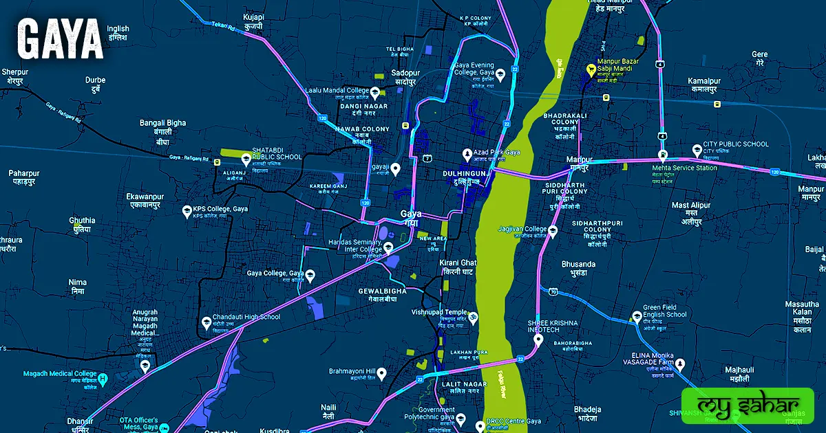
While this city is surrounded on three sides by Brahmayoni, Shringa-Sthan, Ram-Shila, and Mangala-Gauri hills, on another side Falgu river is situated. The religious places here are considered to be very special and important for Hindus, Jains, and Buddhists. Because there are more than 40 religious places located here.
It can also be called the birthplace of Buddhism because it is here that Lord Buddha attained his inner enlightenment. Even this city is mentioned in Mahabharata and Ramayana. According to this Lord Shri Ram, Lakshman, and Mother Sita came here for the Pind-Daan of their ancestors.
It is believed that it was named after a “demon Gayasur” of ancient times. It used to be a part of Ramgarh before the year 1865. Which was later separated from that district. According to the census, a total of “4 lakh 70 thousand” people reside in this city. There is a sex ratio of 986 females for every 1000 males. People here use Hindi, Magahi, Urdu, and English languages.
Famous Roads.
- Tekari Road
- Katari Hill Road
- Shuvam Sarkar Road
- Kharkhura Main Road
- Rajauli Road
- Goutam Buddha Road
- Bodhgaya Road / Godhwari Road
- Mokama / Navada / Laxmipur Road
- Patana – Gaya – Dobhi Road
- White House Compound Road
- Hare Krishna Road
- Gouri Road
- Gaya Rafiganj Road
- Police Line Road
- Sherghati Road
- Church Road
- Pretshila Road
- Tikuna Bypass Road
Famous Chowks.
- Bhagavan Sarthi Gaya Chowk
- Gol Bazar Chowk
- Gewalbigha More
- Sikaria More
- Gol Pathar Chowk
- Saguna More
- Mufassil More
- Ramshila More
- Gandhi More
- Shahmir Takiya More
- Asha Singh More
Rivers And Lakes.
- Falgu River
- Digghi Talab
- Bisar Talab
- Ram Sagar Tank
- Vaitarni Talab
- Brahmsatya Talab
- Haveli Talab
- Rukmini Talab
- Surya Mandir Lake
Ways Of Transportation.

Transportation is an essential element for the development of any city, which connects the city with many other cities and also makes trade easier. The following are the means of transportation here. The major ways of transportation here are roads, rail roots, and airways.
Roads – NH-120, NH-22, SH-4, and SH-70 are the four National Highways passing through this city, which connect its neighboring cities like Rajauli, Nawada, Dobhi, Islampur, and Daudnagar.
Railways – This city has a station called (Gaya Junction), Its station code is (GAYA), which is a junction with routes to several cities. The length of this station is about 803.41 meters and the width is about 91.70 meters. A total of 105 trains run at this railway station.
Airways. – It has an airport called (Gaya International Airport) which is an international airport so people can fly to other countries from here. It is situated 8.5km away in the south direction of the city.
Pin Code Of City.
people also search on Google what is the pin code of this city. The full form of Pin Code is Postal Index Number Code. And the pin code of the city’s head office is – “823001”.
Distance From Major Cities.
- Bihar – 68 km
- Patna – 91 km
- Arrah – 93 km
- Bokaro – 149 km
- Muzaffarpur – 153 km
- Munger – 162 km
- Ranchi – 164 km
- Darbhanga – 178 km
- Dhanbad – 183 km
Latest Weather Updates.
Its’s maximum average annual temperature is around 31.9 °C and the average minimum is around 19.2 °C. And it receives an average of 1,061 millimeters (41.80 in.) of rainfall every year. To get today’s weather information in this town, click on the link given below.
- Weatherbug.com
- Weather15days.in
- City.imd.gov.in
- Gismeteo.com
News Agencies.
A list of some famous local news agencies is given below. These include newspapers, magazines, local news channels, etc.
- Gaya Darshan
- Mahadeva Distribution
- Prabhat Khabar
- HT Media Ltd.
- Hindustan Press
Best Parks.
- Bodh Gaya Water Park
- Jai Prakash Udyan
- Anugrah Vatika Downstream Vatika
- Anugrah Puri Park
- Floral Diversity Park
- Raja Baba Garden
- Azad Park
- Sujata Park
Best Hospitals.
- LifeLine Multispecialty Hospital
- Atlantis Hospital
- Gaya Hospital Pvt. Ltd.
- AIIMS Hospital
- Madhuri Nursing Home
- Kumar Multi-Specialty Hospital
- Apollo Hospital
- JK Memorial Hospital Pvt. Ltd
- Jindal Hospital and Endo-Surgery Centre
- Prakash Multispecialty Hospital
Best Hotels.
- Hotel Virat International
- Hotel Grand Palace
- Sukhdev Clarks International
- Hotel Pataliputra Vishnu Vihar
- Hotel Aryavart
- Hotel Durbar International
- Hotel Taj Darbar Business Hotel
- Mahabodhi Hotel Resort
- Hotel Manisha International
- Hotel Oaks
Best Schools.
- DAV Public School Rotary Campus
- Army Public School OTA
- Creen Memorial High School
- Elegant Public School
- Secondary Delhi Public School
- Hansraj Public CBSE School
- Green Field English School
- Subhash International School
- Podar International School
- Nazareth Academy
Best Colleges.
- Gaya College of Engineering
- Sanjay Gandhi Mahila Inter College
- Anugrah Narayan Magadha Medical College
- Gautam Buddha Women’s College
- Mirza Ghalib College
- Ambed College SN Sinha Bhawan
- AM College
- Gaya Evening College
- Mahesh Singh Yadav College
- Govt. College
Geography Of Gaya.

Its STD code is – 0631. Its height is about 111 meters above sea level. Here the registration of vehicles is done in “BR-02”. The area of this city is (27.19 km²) and the border is about 31.19 km. There is a total of “8 Police Stations” situated in this city.
Official Government Websites.
- Official website of this city – Click here.
- Municipal Corporation’s website – Click here.
- Official Police Website – Click here.
Famous Areas Of City.
- Dulhijung
- Ranipur
- Kirni Ghat
- Durga Bari
- Sohay
- Manpur
- Karim Ganj
- Janakpur
- Lalit Nagar
- Kendua
- Lakhanpura
- Gewal Bigha
- Bhusanda
Famous Places To Visit.
Tourist Attractions –
- APR City Centre Mall
- Brahmayoni Hill
- Masautha kalan (Villege)
- Surya Kund
- Sita Kund
- Falgu Manpur Bridge
- Gaya Museum
- Azad Park Gaya
- Sujata Park
- Singra Asthan
- Bombay Bazaar
- Smart City Center
- Shimpl waterfall
- Sonu Tea Stall
- Kendui Ghat
Temples & Mosques –
- Maa Mangla Gauri Mandir
- Vishnupad Mandir
- Moriya Ghat Masjid
- Murarpur Masjid
- Jama Masjid
Restaurants & Cafes –
- Matangi (Cafe)
- Blackheart Cafe
- Coffee Roaster’s
- Masala Twist Cafe and Restaurant
Movie Theaters –
- APR Cinemas
- Paradise Cinema Hall
- Prem Talkies