Dhule | Maharashtra | Mysahar.in

About Dhule Maharashtra.
Dhule is a well-known commercial city located 53km away from Malegaon, in the state of northwestern Maharashtra. It’s a part of Dhule District. This city is known for its agriculture, cotton, oil manufacturing, milk products, power plants, manufacturing of cotton textiles or turbans, and saris made of special types of yarn. It should not be a surprise if Dhule is considered a paradise for businesses and traders.
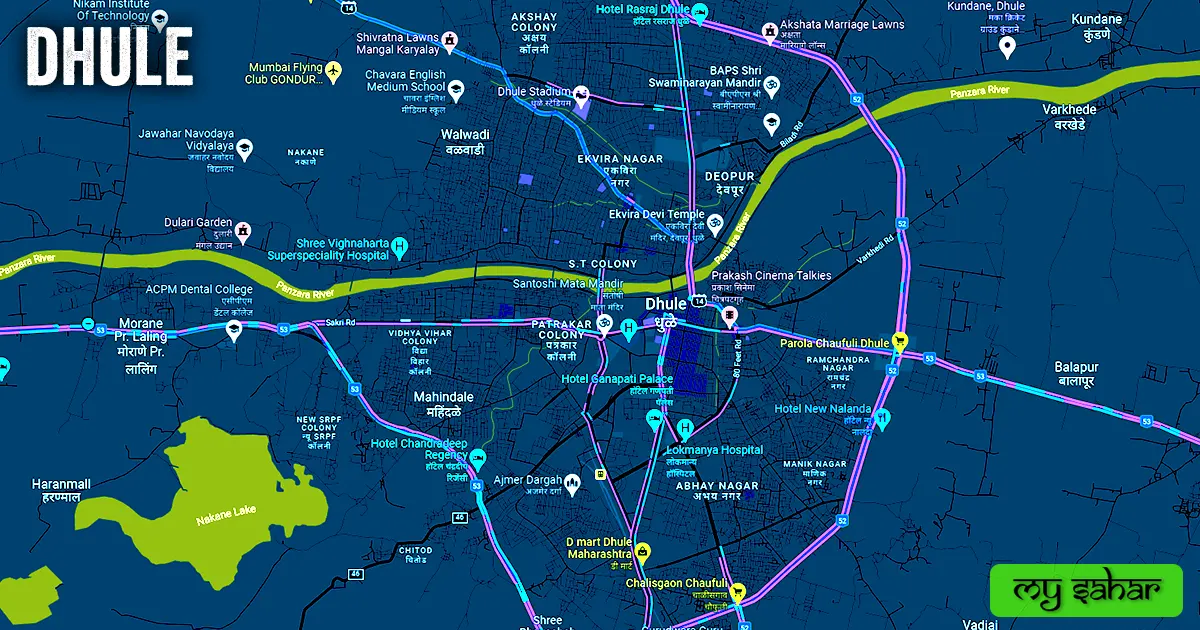
What can be the best place for any business or industry to run efficiently is security, roads, water sources, and ports. Fortunately, Dhule city is situated near two hills Satpura and Satmala hills. Here the Panjara River passes through the center of the city. And three national highways pass here along with the railway station for commercial movement.
Also, due to the proximity of Dhule to Surat, the port is available at a distance of only 227km from here. All these things together make Dhule the best place for doing any kind of business. Most of the crops grown here like groundnut, millet, chili, and maize are exported to other cities. It is also known for its wind power plant.
Dhule was known as “Dhulia” during British rule. It was annexed by the British in 1818 after the Mughals, Marathas. Ultimately, Dhule continues to be a developing and fast-paced industrial revolution. According to the 2011 census, about “3 lakh 75 thousand” people live here. Where there is a sex ratio of 924 females for every 1000 males. The people of Dhule mainly use Marathi, Khandeshi, Bhili, and Hindi languages in their everyday life.
Famous Roads.
- Mumbai Agra National Highway (NH-52)
- Solapur National Highway (NH-52)
- Mumbai Nagpur National Highway (NH-53)
- Malegaon Road
- Wadibhokar Road
- Motha Bridge
- Ganpati Bridge
- Veer Savarkar Marg
- Sakri Road
- Model Road
- N Panjara Highway
- Gondur Airport Road
- Agra Road
- Biladi Road
- Vaekhede Road
- S panjara Highway
- Ekvira Devi Temple Road
Famous Chowks.
- Agrasen Maharaj Putla
- Mahatma Gandhi Putla
- Santoshi Mata Chowk
- Lenin Chowk
- Akbar Chowk
- Narendra Chowk
- Navbharat Chowk
- Sanghama Chowk
- Ahmed Madni Chowk
- Pratap Chowk
- Yuva Millat Social Group Chowk
Rivers And Lakes.
- Panzara River
- Nakane Lake
- MIDC Lake
Ways Of Transportation.

Transportation is an essential element for the development of any city, which connects the city with many other cities and also makes trade easier. The following are the means of transportation in Dhule. The major ways of transportation here are roads, rail roots, and airways.
Roads – NH-52, NH-52, NH-60, SH-14, and MRD46 are the five state and national highways that pass through Dhule, which connect this city to its big neighbor cities like – Sakri, Parola, Amalner, Chalisgaon Songir, and Malegaon together.
Railways – Dhule has two railway stations called (Dhule Station and Mohadi Station). the first one is the main major station. Its main station’s station code is (DHI). Its length is about 610.83 meters and its width is about 61.30 meters. a total of 4 trains arrive here and it has 1 platform in operation.
Airways – Dhule doesn’t have its own airport. so for any flight, you have to go to its nearest airport known as (Jalgaon Airport) which is located 101 km away in the west direction from here in Jalgaon city. It takes 2 hours and 24 minutes to reach there.
Pin Code Of City.
people also search on the internet that what is the pin code of Dhule city. The full form of the PIN Code is Postal Index Number Code. And the pin code of the city’s Head Office is – “424001”
Distance From Major Cities.
- Parola – 38 km
- Malegaon – 52 km
- Nampur – 64 km
- Aurangabad – 128 km
- Nashik – 144 km
- Burhanpur – 157 km
- Jalna – 165 km
- Surat – 196 km
- Ahmadnagar – 201 km
- Vadodara – 226 km
Latest Weather Updates.
The average temperature of this city is around 32°C in summer and 19°C in winter. And here on average 595.63mm (23.45 inches), every year of rainfall happens. It rains here for about 119 days every year. For today’s weather information about Dhule, click on the link given below.
- Weather-forecast.com
- Weather15days.in
- Ventusky.com
Watch YouTube Video.
Don’t Want to read, watch the Mysahar video instead and get all of your answers about Dhule.
News Agencies.
A list of some famous local news agencies is given below. These include newspapers, magazines, local news channels, etc.
- Economic Times
- Navarashtra
- Maharashtra Times
- Saam TV
- Punekar News
- The Quint
- Sarkar Nama
Best Parks.
- Dama Garden
- Shiv Tirth Park
- Lumbineevan Parisar Udyan
- Tuljai Ground
- Professor Colony Park
- Krishna Mandir Udyan
- Sai Nath Garden
- Sardar Patel Tower Garden
- Punyashlok Udyan
- Sambhaji Garden Zende Bhavan
Best Hospitals.
- Siddhi Maternity Hospital
- Thakare Hospital
- Dhandai Hospital
- Govt Medical College & Hospital
- Siddheshwar Multi Speciality Hospital
- Shree Vighnaharta Superspeciality Hospital
- Anjana Heart Hospital
- Shree Siddheshwar Hospital
- District Hospital
- Om critical care center Pvt. Ltd
Best Hotels.
- Hotel Residency Park
- Hotel Ganapati Palace
- Hotel New Mayur
- Taquila (Veg Restaurant)
- Kanha Regency
- Hotel Yash President
- Hotel Manas
- Hotel Rasraj
- Nav Shere Punjab Lodge
- Hotel Chandradeep Regency
Best Schools.
- The Bombay Flying Club’s College Of Aviation
- Cambridge International School
- Dollys’ House English Medium School
- R P S English Medium School
- Kendriya Vidyalaya
- Unnati Primary & Secondary High School
- Chavara English Medium School
- Rabindranath Tagore English Medium School
- R.M.Patel Urdu High School
- Kamlabai Girls High School
Best Colleges.
- S.S.V.P.S’s College of Engineering
- A.C.P.M Medical College
- S.S.V.P.S’s Science College
- Adarsh Polytechnic
- Zulal Bhilajirao Patil College
- College of Agriculture
- M.D. Palesha Commerce College
- SVKM’s Institute of Technology
- Shikshan Maharshi Dadasaheb Rawal
- Shree Bhausaheb Hire Govt Medical College
Geography Of Dhule.

STD code of This city is “02562” Its height is about (319 meters) above sea level. Here the registration of cars and bikes is done in “MH-18”. The area of Dhule is (170 square kilometers). There is a total of “3 Police Stations” located here.
Official Government Websites.
- Official website of Dhule district – Click here.
- Municipal Corporation’s website – Click here.
- Official Police Website – Click here.
Famous Areas Of City.
- Shriram Nagar
- Mahindale
- Abhay Nagar
- Unnati Nagar
- Deopur
- Walwadi
- Rajendra Nagar
- Awadhan
- Oswal Nagar
- Kumar Nagar
- Navnath Nagar
Famous Places To Visit.
- Motha Bridge
- B Square Shopping Mall
- Shri Samartha Vagdevta Mandir
- burani complex
- Songir Fort
- Bhansali Plaza
- Hotel Gulshan Permit Room and Beer Bar
- Shri Swaminarayan Mandir
- Nkane Lake
- Laling Fort
- Shree Siddheshwar Ganesh Mandir
- Moglai Jama Masjid
- Thalner Fort
- Datta Mandir
- Mumbai Street Food Court
- Swami Narayan Temple
- Masala Chowk
