Discovery of Burhanpur | Mysahar.in

About Burhanpur Madhya Pradesh.
The city of Burhanpur is situated 70 km away from Khandwa in the state of western south Madhya Pradesh. Many ancient palaces, mosques, tombs, forts, and monuments are located here, and archaeological explorers have also found historical temples, statues, and gold coins. Apart from this, small-scale industries and manufacturers are also functioning here. Cultivation is done in the surrounding areas of Burhanpur, in which most of the banana gardens are grown, along with it Soybean, Wheat, Gram, Arhar, and other Pulses are also grown. Tapi River, the only river here flows in the east of the city, which makes farming very easy here.
Burhanpur is the biggest center of the power loom industry in Madhya Pradesh. Which is famous all over the country for the production of various types of yarn fabrics, the fabrics made here are also exported to foreign countries. These fabrics include cambric fiber fabrics, dhoti, buckram fabrics, cotton fabrics, etc. For whose production many textile mills are located here. Apart from textile mills, many small industries like Rope manufacturing factories, Ice factories, Textile manufacturers, Textile mills, Plastic Products manufacturers, and Oil Mills are also located in Burhanpur.
Burhanpur was founded in 1399 by a king named Prince Nasir Khan who was the first independent prince of the Farooqui dynasty of Khandesh. Some monuments of the time of the Mughals are still important centers of tourism here like – Dargah-E-Hakimi, Shahi Qila, Black Tajmahal Burhanpur, and Shahi Hamam (Royal Bath of Queen Mumtaz). Also, there is Blue Waves Aqua Park 11 km east from here, thousands of tourists come to visit all these tourist places every year, due to which the city gets a lot of economic benefits. According to the census, more than 2 lakh 10 thousand people live here, and mainly Hindi is used, in some parts Marathi is also used by the people.
Famous Roads.
- Khandwa / Indore Highway
- Shahpur / Jalgaon Highway
- Jalgaon Jamod / Amravati Highway
- Raver Road
- Old Nagar Nigam Road
- Lohar Mandi Road
- Lalbagh Road
- Tilak Road
- Mahajanapeth Road
- Shikarpura Road
- By Pass Road
- Rajpura Road
- Renuka Mata Road
Famous Chowks.
- Sindhi Basti Square
- Shanwara Gate
- Pandumal Chouraha
- Gandhi Chowk
- Jai Stambh Chowk
- Ganpati Naka
- Bajrang Chowk
- Shivaji Chowk
Rivers And Lakes.
- Tapi River
- Utawali River
- Renuka Lake
- Pandarol Nala
Ways Of Transportation.

Any city’s ability to develop is greatly influenced by its transportation infrastructure, which connects it to a number of other towns and promotes commerce. The following list of transit options is provided: Burhanpur’s primary means of transit consist of roads, train lines, and aircraft.
Roads – Three State highways, SH-27, SH-4, and SH-50, connect Burhanpur to other neighboring areas, like Raver, Jalgaon, Jamod, Amravati, Khandwa, and Indore.
Railways – Burhanpur has a railway station, called Burhanpur. The station’s code is (BAU). Its width is 35.71 meters, and its length is about 628.37 meters. It’s part of the Central Railway, A total of 42 trains are operating from this station.
Airways – Burhanpur doesn’t have an airport. Therefore, everyone traveling by air must fly to the nearest airport (Jalgaon Airport). this airport is located 98km from Burhanpur City in the western-south direction. To reach there, it takes around 2 hours and 4 minutes.
Pin Code Of City.
On the internet, people also search for this city’s pin code. The PIN code’s full name is Postal Index Number Code. And the pin number of Burhanpur city is “450331”.
Distance From Major Cities.
- Khandwa – 70km
- Jalgaon – 88km
- Jalgaon Jamod – 59km
- Indore – 181km
- Muktainagar – 40km
- Amravati – 200km
- Dhule – 193km
- Raver – 22km
- Rama Kheda Khurd – 80km
- Ujjain – 240km
Latest Weather Updates.
The typical temperature of Burhanpur is approximately 26°C. 40°C is the highest recorded, and 14°C is the winter record. And the annual average rainfall in this area is 555.20 mm (21 inches). Here, it rains for roughly 118 days a year. Below are some to get the local weather for today.
- weather.com
- weather-forecast.com
- qweather.com
Radio Stations.
Below is a list of radio channels broadcasted by neighboring cities of Burhanpur. As Burhanpur itself does not have any local radio broadcasters, people here tune in to the nearest radio stations.
- 91.1 MHz – Radio City, Jalgaon (Music Broadcast Ltd)
- 94.3 MHz – MY FM, Jalgaon (DB Corp Ltd)
- 98.3 MHz – FM Tadka, Jalgaon (Rajasthan Patrika Pvt Ltd)
- 101.2 MHz – All India Radio (AIR Khandwa / Akashvani Khandwa)
- 102.1 MHz – All India Radio Jalgaon (AIR Jalgaon / Akashvani Jalgaon)
- 106.4 MHz – Radio Dhamaal 24, Jalgaon (Skyline Radio Network Ltd)
Best Parks.
- Blue Waves Aqua Park
- City Park
- Sanjay Nagar Garden
- Sardar Patel Garden
- Sager Tower Graund
- Chatrapati Shivaji Maharaj Pratima Graund
- Utawli Rivar Graund
- Renuka Mata Temple Garden
- Atal Smriti Sthal
Best Hospitals.
- Metro Multispecial And Dental Hospital
- Apple Hospital
- Dr. Gawde’s Yashwant Memorial Deaddiction Center
- Precious Life Care Hospital
- Borle Hospital
- District Hospital Burhanpur
- Rashabai Shivchand Chudiwal Memorial Nimar Hospital
- Krishna Life Care
- Hakimi Hospital
- Radheshyam Ashirwad Hospital
Best Hotels.
- Utsav Hotel And Resort
- Hotel Amber And Holiday Resort
- Hotel Panchvatika
- Mann Holiday Resort
- Hotel High Rise Regency
- Hotel Grand Shivam
- Ambika Hotel
- Hotel City Plaza
- Hotel Shri Maya
- Hotel Radhe Krishna
Best Schools.
- Macro Vision Academy
- Nehru Montessori Senior Secondary School
- St. Theresas School
- Arwachin India School
- Burhanpur Public School
- St. Xavier’s International School
- Adarsh Vidhyapeeth Higher Secondary School
- Shri Deochand Sapkale Memorial Society ICSE
- Kendriya Vidyalay Burhanpur
- Quaderia Burhani School
Best Colleges.
- Seva Sadan Mahavidhyalay Shanware
- Thakur Shivkumar Singh Memorial Engineering College
- Jijamata Polyechnic College
- Guru Gobind Singh College Of Dental Science And Research Center
- Pt. Shivnath Shastri Auto Govt. Ayurved College
- Govt. ITI College Burhanpur
- Saifia Hamidia Unani Tibbiya College
- Zakir Husain College
- Saifee Golden Jubilee Quaderia College
- Government College Burhanpur
Geography Of Burhanpur.

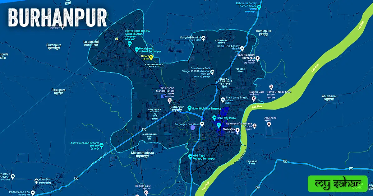
Burhanpur has an STD code of (07325) and is situated around 247 meters above sea level. Vehicle registration is carried out at “MP-68” in this location. This city has a (17.15 km²) square area and the boundary is around 19.22 km long. There are a total of “04 Police Stations” located here.
Official Government Websites.
- Official website of Burhanpur – Click here.
- Municipal Corporation’s website – Click here.
- Official Police Website – Click here.
Famous Areas Of City.
- Mohammadpura
- Monin Pura
- Jamal Pura
- Dakwadi
- Laxmi Mata Nagar
- Lalbag RYT
- Naval Nagar Jhiri
- Sanjay Nagar
- Saraswati Nagar
- Naya Mohalla
- Patidar Colony
- Sindhi Basti
Famous Places To Visit.
Tourist Attractions –
- Shanwara Gate
- Shahi Quila
- Blue Waves Aqua Park
- Black Tajmahal
- Shahi Hama Of Queen Mumtaz
- Fort Wall (Tapi River Side)
- Kundi Bhandara
- Barah Dari
- Ahukhana and Pavilion
- Utsav Water Park
Temples & Mosques –
- Dargah-E-Hakimi
- Shahi Jama Masjid
- Shani Mandir
- Shri Bade Balaji Mandir
- Ganpati Temple
- Jain Swetamber Shantinath Tirth
Restaurants & Cafes –
- Kishor Garden Restaurant
- Anand Green Restrauant
- Gokul Midway Restaurant
- Hariyali Family Garden & Restaurant
- Kundan Dhaat Choupati
- The Click Cafe
Movie Theaters –
- Ankita Multiplex
- Star Cinemas
- Samkar Talkies
- Gursikh Goldmark Cinemas
Shopping Malls –
- Tulsi Mall
- Gursikh Mall
- Reliance Smart Store