Discovery of Rajnandgaon | Mysahar.in

About Rajnandgaon Chhattisgarh.
Rajnandgaon is a city located in Chhattisgarh which is famous all over the state for its temples, food, agriculture, and tourist places. Maa Bamleshwari Temple situated here is quite famous. On the other hand, when it comes to agriculture, pulses, rice, jowar, and millet are grown in large quantities here.
Due to the only flowing Sivnath river, it becomes quite easy to do farming here. Apart from agriculture, animal husbandry is also a major source of income for the people here. Which goat, poultry, cow, and fish farming are included. Along with this, the fruits of the “Mahua” trees found here are also made and sold as drinks, which are intoxicating like alcohol.
The dishes prepared here are famous all over the state, in which local dishes like – Cheela, Chaura Roti, Angkar Roti, Kochai Bhaji, “Idhar” and Chutney are included. This city was called Nandgram in the 19th century. Which used to be a part of the Durg district itself. On 26 January 1973, it was divided from the Durg and made a separate city.
Talking about the industries and factories here, the cotton textile industry, paddy mill, pulse mill, and food processing mills are included. Its nearest airport is “Swami Vivekananda International Airport” which is located in Raipur, about 89 km from here. About “1 lakh 63 thousand” people reside in the city. Who use Hindi, and Chhattisgarhi languages in their daily lives.
Famous Roads.
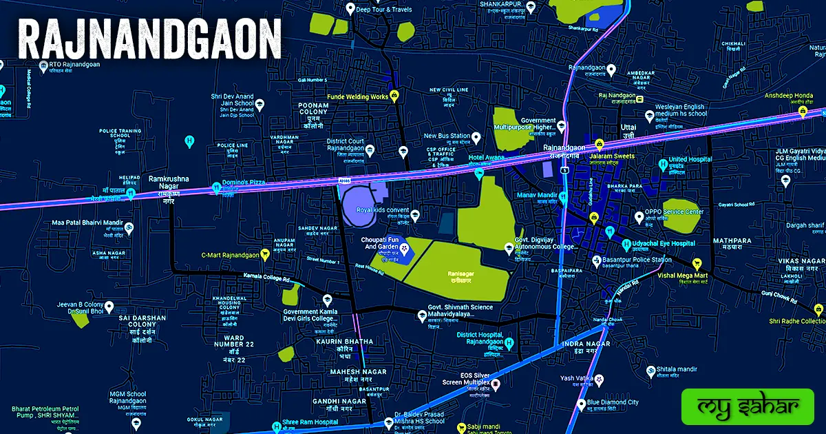
- Dalli Rajhara Road
- Mumbai Kolkata Highway NH 53
- Khairgarh Road
- Dongargaon Road
- Power House Road
- Station Road
- Kamla College Road
- Rani Sagar Road
- Gourav Path
- Lakholi Road
- Gaushala Road
- Tulsipur Main Road
- Digvijay College Road
- Bypass Road
- Gunj Chowk Road
- Basantpur Road
- Nandai Road
Famous Chowks.
- Imam Chowk
- Nandai Chowk
- Manav Mandir Chowk
- Jaistambh Chowk
- Ganj Chowk
- Gunj Chowk
- Gurudwara Chowk
- Stadium Chowk
- Anupam Nagar Chowk
- Indra Nagar Chowk
- Club Chowk
- Kunwa Chowk
- Bharat Mata Chowk
- Bhadauria Chowk
- Tiranga Chowk
Rivers And Lakes.
- Shivnath River
- Rani Sagar Lake
- Budha Sagar
- Bada Talab
- Chota Talab
- Moti Talab
- Indra Sarovar
- Chikhli Talab
- Motipur Kai Talab
- Nava Gaon Patel Talab
- Dabari
- Kaurin Bhata Talab
Ways Of Transportation.

Transportation is an essential element for the development of any city, which connects the city with many other cities and also makes trade easier. The following are the means of transportation here. The major ways of transportation here are roads, rail roots, and airways.
Roads – NH-53, SH-5, and Dongargaon Highway are the three National Highways passing through this city, which connect – Durg, Sadak Arjuni, Dalli Rajhara, Khairagarh, and Dongargaon together.
Railways – This city has a railway station in the northeast of the city. Its station code is (RJN). The length of this station is about 647.08 meters and the width is about 75.03 meters. A total of 186 trains run at this railway station.
Airways – This city has helipads but doesn’t have an airport. so for flights you have to go to its nearest airport which is (Swami Vivekananda International Airport) Located in Raipur city. which is 87.6 Kilometers far from here and it takes about 2 hours to come here by road.
Pin Code Of City.
People also search on Google what is the pin code of this city. The full form of a Pin Code is Postal Index Number Code. And the pin code of this city’s head office is – “491441”.
Distance From Major Cities.
- Dongargaon – 25 km
- Durg – 30 km
- Dongargarh – 34 km
- Khairagarh – 39 km
- Bhilai – 42 km
- Dalli Rajhara – 62 km
- Raipur – 81 km
- Kawardha – 116 km
- Bhandara – 153 km
- Bilaspur – 186 km
Latest Weather Updates.
It has an annual average high temperature of 30.5°C and an average minimum low temperature of about 20.1°C. And it receives an average of 1080 millimeters (42.52 in.) of rain every year. It rains for 52 days a year. Below are some websites from where you can get weather information.
- www.foreca.com
- whitelightsky.com
- wanderlog.com
- www.msn.com
- meteoin.ru
- goodmeteo.com
News Agencies.
A list of some famous local news agencies is given below. These include newspapers, magazines, local news channels, etc.
- Taj News Agency
- Krantikari Sanket
- Dainik Dawa
- Sabera Sanket
- Krantikari Sanket
- Shivnath Samvad e-News
- Press Reporter Club
Best Parks.
- Aqua Village Water Park And Resort
- Mangata Park
- Choupati Fun And Park
- Shivnath Vatika
- Energy Park
- Nehru Park
- Amrit Vatika
- Children Park
- Mahesh Nagar Garden
- Green City Park
Best Hospitals.
- Chhattisgarh ENT Care Hospital
- Sai Kripa Hospital
- Shukla Mutispeciality Hospital
- Medicity Hospital
- District Hospital
- BSR Superspeciality Hospital
- DNA Critical Care Hospital
- Shree Ram Hospital
- Bhadauria Nursing Home & Fertility Clinic
- Shree City Hospital
Best Hotels.
- Hotel Raj Imperial
- Hotel Awana
- Hotel Shri Kanwar Palace
- Hotel Gujrat Inn
- Hotel Amora
- The Singh’s Hotel
- Hotel Laxminarayana
- Hotel Panchsheel Prime
- Hotel Railies
- ABIS Lakeside Hotel
Best Schools.
- Yugantar Public School
- Weidner Memorial English Medium S.S. School
- JLM Gayatri Vidya Peeth English Medium School
- Neeraj Public School
- Bal Bharti Public School
- Wesleyan English Medium H. S. School
- Shri Dev Anand Jain School
- Government Multipurpose H.S. School
- Neeraj Parents Pride School
- JMJ Navjeevan School
Best Colleges.
- Govt. Digvijay Autonomous College
- Atal Bihari Vajpayee Medical College
- Govt. Shivnath Science Mahavidyalaya
- C.G. Institute Of Technology
- Government Medical College
- Govt. Kamla Devi Girls College
- Royal College
- Cadence Academy Of Design
- Govt. College Of Nursing
- Chikhali Confluence College
Geography Of Rajnandgaon.

The area code of the city is – (07744). Its height is about (307 meters) above sea level. Here the registration of vehicles is done in “CG-08”. The area of this city is (17.15 km²) and the border is about 25.72 km. There’s a total of “7 Police Stations” situated in this city.
Official Government Websites.
- Official website of this city – Click here.
- Municipal Corporation’s website – Click here.
- Official Police Website – Click here.
Famous Areas Of City.
- Motipur
- Chikhali
- Tulsipur
- Baspai Para
- Mathpara
- Basantpur
- Lakholi
- Anupam Nagar
- Shankar Nagar
Famous Places To Visit.
Tourist Attractions –
- Managata Wildlife Park
- City center mall
- Rani Sagar Lake
- Nehru Park
- Energy Park
- Sumit Mandi Mall
- Choupati Fun And Garden
Temples & Mosques –
- Patal Bhairavi Mata Mandir
- Shree Ram Darbar Mandir
- Sai Baba Mandir
- Shwetamber Jain Mandir
- Sri Balaji Mandir
- Jalaram Mandir
- Kali Mai Mandir
- Shiv Mandir
- Shree Shiddhivinayak Temple
Restaurants & Cafes –
- Manav Mandir (Resturaunt)
- Jalaram Sweets
- My Chai Hut (Cafe)
- Fursat Ke Pal (DIne-In)
- Kolkata Chicken Center
- Urban Cafe
- Shree Ram Dabeli Centre
- Mahendra Chat Corner (Fast Food)
- Munna Mungodi (Fast Food)
- Greek Cafe & Resturaunt
- Amigao’ The Cafe
- Popeye The Juice & Snacks World
- ABIS Chicken Delight
Movie Theaters –
- EOS Silver Screen Multiplex
- Krishna Talkies